SLAM, RTK-SLAM and PPK-SLAM modes help buyers cover both GNSS and GNSS-denied mapping environments with one handheld scanner.
← Back to GNSS Application SolutionsHandheld LiDAR SLAM scanner
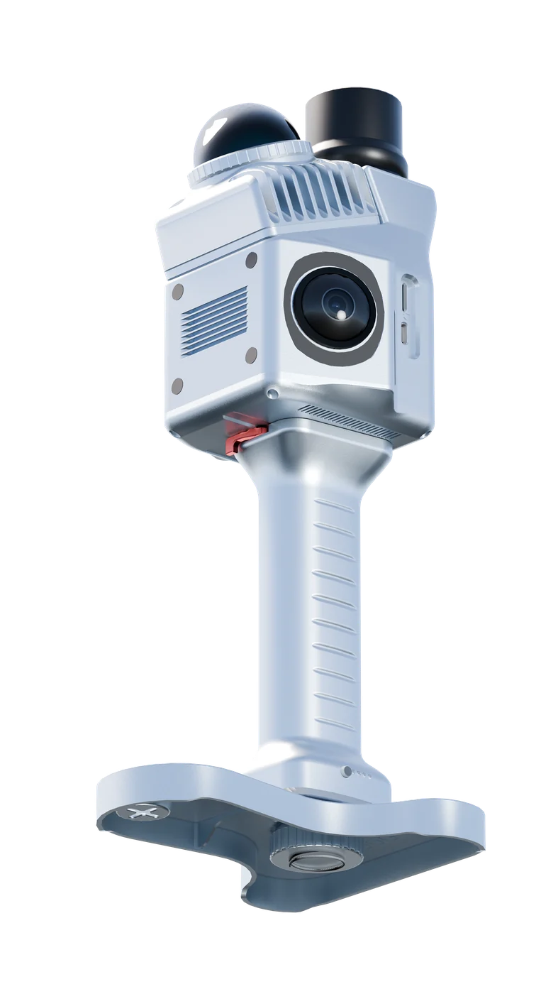
TSR20 Handheld LiDAR SLAM Scanner
Lightweight real-time mapping LiDAR system for indoor and outdoor 3D point cloud capture in GNSS and GNSS-denied environments.
Mapping modeSLAM / RTK-SLAM / PPK-SLAM
Accuracy≤3cm relative, ≤5cm absolute
Scan rate200,000 points/sec
Weight1.0kg including battery
Key Features
✓Livox Mid-360 LiDAR
✓SLAM / RTK-SLAM / PPK-SLAM modes
✓1.0kg handheld design
✓Dual 20MP cameras
✓200,000 points/sec
✓Up to 5cm absolute accuracy
Buyer-focused value
Why overseas buyers choose this model
Structured for dealers, contractors and system integrators comparing receiver performance, kit completeness and after-sales preparation.
The 1.0kg body, Livox Mid-360 LiDAR and dual 20MP cameras support fast field capture for indoor mapping, digital twins and infrastructure inspection.
Built-in storage, Wi-Fi transfer and dedicated post-processing workflow make it easier for dealers to demonstrate a complete 3D scanning solution.
Applications
Typical project scenarios
Use the application cards as a quotation starting point. TOKNAV can confirm the final kit after checking project environment and delivery requirements.
Recommended configuration and accessories can be confirmed according to the project site, correction method and buyer's country.
Recommended configuration and accessories can be confirmed according to the project site, correction method and buyer's country.
Recommended configuration and accessories can be confirmed according to the project site, correction method and buyer's country.
Recommended configuration and accessories can be confirmed according to the project site, correction method and buyer's country.
Recommended configuration and accessories can be confirmed according to the project site, correction method and buyer's country.
Brochure-based details
Complete Specifications
The table below organizes key parameters from TOKNAV catalogs and model datasheets into procurement-friendly groups for easier comparison.
SLAM Mapping System
Mapping modeSLAM, RTK-SLAM and PPK-SLAM
Accuracy≤3cm relative accuracy and ≤5cm absolute accuracy listed in TSR20 EN brochure
Point cloud thickness1cm
Point cloud update frequency10Hz
Typical applicationsUnderground, indoor, stairs, parking lots, outdoor buildings, low-canopy forest and power line patrol
LiDAR and Camera
Laser sensorLivox Mid-360 LiDAR
Measuring range40m at 10% reflectivity
Scan rateSingle echo, 200,000 points/sec
Field of viewHorizontal 360 degrees; vertical -7 degrees to 52 degrees
Range accuracy≤2cm at 10m, ≤3cm at 0.2m
CameraDual 20MP cameras with 200-degree ultra-wide time-synchronized scanning
GNSS / POS
GNSS systemGPS L1/L2/L5, GLONASS L1/L2, Galileo E1/E5a/E5b and BDS signals listed in brochure
Positioning accuracyHorizontal +/-0.02m, vertical +/-0.03m
IMU update rate200Hz
Pitch accuracy0.015 degrees
Roll accuracy0.015 degrees
Heading accuracy0.040 degrees
Hardware and Storage
Dimensions16.5 x 12.0 x 32.4cm
Weight1.0kg including battery
Operating temperature-20°C to 55°C
System consumption25W
Storage64GB internal flash memory and 128GB MicroSD card support
Wi-Fi transmissionSmooth data reception within 5m
Downloads and inquiry package
Get Catalog, Datasheet and Quote Support
Download the category brochure or send the model requirement directly to TOKNAV sales for the latest datasheet, price and recommended accessories.
Ready for quotation?Send your target quantity and application for TSR20 Handheld LiDAR SLAM Scanner.
Send Requirements →Buyer Notes
Parameters may be updated by the manufacturer. For quotation, distributor cooperation or OEM/ODM projects, please send your target application, quantity, country and required accessories so TOKNAV can confirm the latest configuration.
Procurement FAQ
Common Questions Before Purchase
What is TSR20 Handheld LiDAR SLAM Scanner mainly used for?
TSR20 Handheld LiDAR SLAM Scanner is mainly used for Indoor mapping, Outdoor building scanning, Digital twin modeling, Power line patrol, Forestry and low-canopy survey. Buyers can confirm the final configuration based on project application, country, correction method and accessory requirements.
Can I request the latest datasheet and price for TSR20 Handheld LiDAR SLAM Scanner?
Yes. Use the quote form on this page to request the latest datasheet, price, MOQ, lead time, packing list and recommended accessories for TSR20 Handheld LiDAR SLAM Scanner.
Are the parameters final for every market?
Product parameters may be updated by the manufacturer and can vary by configuration or regional version. TOKNAV should confirm the latest configuration before quotation or shipment.
Procurement support
Get Model Quote →Need help choosing a complete receiver kit?
Send your model, target quantity, market country, application and accessory preference. TOKNAV can prepare a practical quote package for distributor review or project bidding.
 Deformation Monitoring Solution
 CORS and VRS Service Solution
 TR10Pro Line Marking Robot
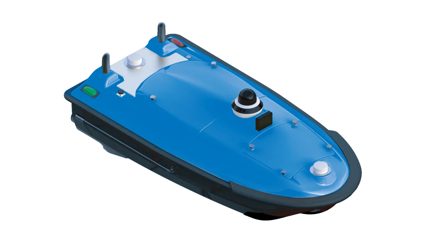 Tboat USV Series